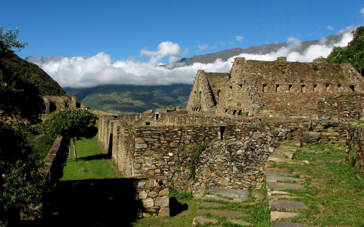
The Choquequirao trek to Machu Picchu is undoubtedly one of the most demanding and surprising treks joining two beautiful Inca citadels, we will pass through different incredible points such as valleys and gorges. We will observe one of the deepest canyons in the world (Cañon de Apurimac). Crossing between the two sacred rivers Apurimac and Wilcamayu (Vilcanota) we enter the best alternative towards Machu Picchu.
Many archaeological studies indicate that Choquequirao and Machu Picchu are Inca cities connected to each other, due to their location, they possibly had Inca roads that linked these two wonderful Inca constructions. CHOQUEQUIRAO is considered one of the last cities inhabited by the Incas, with beautiful buildings in pirka, which is quite different from its sister, the citadel of Machupicchu, where the type of construction is Imperial Inca, here we can see how one of the last incas of Inca resistance still persists while waiting for all travelers who dare to have a 9-day demanding hike.
Like many Inca cities, Choquequirao is characterized by its two very defined sectors, the agricultural sector that is made up of a large number of Andes and terraces, and the urban sector made up of buildings with social functions and ritual centers dedicated to different deities. worshiped by the Incas. MACHUPICCHU is one of the seven wonders of the world, the lost city of the Incas, which receives thousands of visitors per day, many of the main attractions are within the urban. area, highlighting great attractions with unique qualities in its finish such as the temple of the sun, the temple of the three windows, the intiwatana or sundial, etc. Machupicchu is surrounded by mountains, among the main ones is the Huaynapicchu mountain, which can be accessed on foot and where we can find important archaeological sites as well as a panoramic view of Machu Picchu.
We invite you to explore and discover this beautiful trek from Choquequirao to Machupicchu, and we are sure that this beautiful trekking route will exceed your expectations, along with safety and the best service from our great team of professionals.
| Altitude during the trek | Weather | |
| Cusco | Capital: 3,350 m.s.n.m. (Cusco) Minimum: 2,000 m.s.n.m. (Playa Sahuayaco) Maximum: 5,085 m.s.n.m. (Abra Sacsarayoj) | Semi-tropical, hot and humid days and cold nights with constant rain throughout the year Minimum: Between -5 ° C to 11 ºC Open Sacsarayoj (June) Maximum: Between 20 ºC to 26 ° C Playa Sahuayaco (June) Rains: November to April |
ITINERARY:
Day 1: Cusco – Cachora – Capuliyoc – Chiquisca
Our adventure begins with the pick up from your hotel at 6:00 in the morning for a bus trip heading northwest to the Saywite archaeological center 3,500 masl (11,482 ft) that houses a rock monolith with zoomorphic, phytomorphic figures, geographical accidents and human constructions, we will have a brief visit, continuing the trip we will go to the town of Cachora 2,900 masl (9,514 ft), we will continue to Punta Carretera, to here our mobility will transport us, from here onwards we will continue walking with our staff of support and our mules, we will stop at Capuliyoc 2,885 masl (9,336 ft) to enjoy our lunch and then we will begin the descent to the Chiquisca camp 1,910 masl (6,266 ft), here we will spend the night.
- Total distance: 7 kilometers
- Estimated time: 3 to 4 hours
- Maximum Altitude Point: 3,500 masl (11,482 ft)
- Camp height: 1,910 masl (6,266 ft)
Day 2: Chiquisca – Marampata – Choquequirao
We will continue very early descending to Playa Rosalina 1,500 masl (4,921 ft) above the Apurimac river, from this point we will start to ascend reaching Santa Rosa, a beautiful place with the option of drinking the famous “Cambray”, known as an artisanal drink made from cane. de Azúcar and we will continue ascending to Marampata 2,870 masl (9,416 ft), where we will have our lunch. Later we continue our walk for about 2 hours until we reach the Choquequirao camp area 2,950 masl (9,688 ft), so this day we will camp near the archaeological site.
- Total distance: 17 kilometers
- Estimated time: 7 to 8 hours
- Maximum Altitude Point: 2,950 masl (9,688 ft)
- Camp height: 2,950 masl (9,688 ft)
Day 3: Choquequirao
We will spend the day touring the grandiose Choquequirao Archaeological Center, we will pass point by point getting to know better the constructions that are 40% free of vegetation and this is made up of nine stone architectural groups and a system of 180 platforms, residential, administrative house areas , artisanal, irrigation system, among other buildings built on stone.
- Estimated time: 7 to 8 hours
- Maximum Altitude Point: 3,100 masl (10,170 ft)
- Camp height: 2,950 masl (9,688 ft)
Day 4: Choquequirao – Pinchiunuyoc – Maizal
We will leave the camp early and start our walk for 3 hours until we reach the Pinchiunuyoc archaeological site, recently discovered in 1998. This archaeological site is very special because they suddenly appear outside the cloud forest, almost invisible due to the thick layer of moss and from other vegetation that covers them, in this place we will have our lunch, we will continue the descent towards the White River 1,900 masl (6,233 ft) We will begin a long and steep climb to our camp in Maizal 3,000 masl (9,842 ft), in the upper part from the river – probably the most beautiful camp on the way, with beautiful views of the valley, trees and snow capped peaks. Once in Maizal we will set our camp.
- Total distance: 14 kilometers
- Estimated time: 6 to 7 hours
- Maximum altitude point: 3,300 masl (10,826 ft)
- Camp height: 3,000 masl (9,842 ft)
Day 5: Maizal – Yanama
We leave our camp in Maizal and begin a long climb to the Victoria pass 4,200 masl (13,779 ft) first we walk through the cloud forest and high Andean grasslands, we will have lunch passing this pass, with views of the Choquetakarpo mountain, before we begin the descent Yanama, a small isolated town in the lower part of a very broad valley, surrounded by mountains. Here we will set our camp for the night.
- Total distance: 13 kilometers
- Estimated time: 6 to 7 hours
- Maximum Altitude Point: 4,200 masl (13,779 ft)
- Camp height: 3,500 masl (11,482 ft)
Day 6: Yanama – Totora
This will be the day with the highest demand, we will start with the ascent through the valley to the highest point of the trip, the Yanama pass 4,550 masl (14,927 ft). On the way we will have a good view of the snow-capped Sacsarayoc or Padreyoc and hopefully we will see some condors. As we walk on the pass we can walk on snow. For the descent the road becomes misty and muddy, until we reach the community of Totora 3,600 masl (11,811 ft), where we spend the night.
- Total distance: 15 kilometers
- Estimated time: 7 to 8 hours
- Maximum altitude point: 4,550 masl (14,927 ft)
- Camp height: 3,600 masl (11,811 ft)
Day 7: Totora – Playa – Lucmabamba
After a very early breakfast, we begin our seventh day of excursion, this day we will have a long descent until we reach the town of La Playa 2,400 masl (7,874 ft), descending more than 2,000m, this town is one of the largest on the way, Here we can find small shops to buy some snacks. In this area we can see small coffee and banana plantations. Then we will continue our walk until we reach Lucmabamba 2,000 masl (6,561 ft), this will be the place of our camp, keep in mind that it will be our last night of camping.
- Total distance: 12 kilometers
- Estimated time: 6 to 7 hours
- Maximum altitude point: 3,600 masl (11,811 ft)
- Camp height: 2,000 masl (6,561 ft)
Day 8: Lucmabamba – Aguas Calientes
We will start early with the walk, we will ascend to the Inca city of Llactapata 2,700 masl (8,858 ft), from this place we will be able to see the Inca city of Machupicchu from a different angle, here we will have our lunch, we will continue with the walk descending to the town of Hydroelectric 1,809 masl (5,935 ft), here we will take the train that will take us to the town of Aguas Calientes 2040 masl (6,692 ft) where we will spend the night in a hostel.
- Total distance: 10 kilometers
- Estimated time: 4 to 5 hours
- Maximum altitude point: 2,700 masl (8,858 ft)
- Camp height: 2040 masl (6,692 ft)
Day 9: Aguas Calientes – Machu Picchu – Cusco
We get up early (5:00 a.m.) after breakfast we take the first bus (5:30 a.m.) to Machu Picchu. Once in the Archaeological Park, we will have a guided tour for about 2 hours. Then they will have the rest of the day free to explore the rest of the city. You must be at the train station in Aguas Calientes about 30 minutes before the train departs.
It Includes:
- Professional Guide.
- Chef.
- Mules to carry food, camping equipment and personal belongings (5kg).
- Arrieros.
- Informative meeting before the trip (2 days before departure, the place will coordinate with you).
- Pick up from your accommodation.
- Transportation from Cusco to Cachora – Punta Carretera (starting point of the trek).
- Double tents and Matras.
- Camping equipment: kitchen tent, dining tent, chairs, tables and W.C. in all the camps.
- First aid kit.
- 8 Breakfasts, 8 Lunches and 8 Dinners
- Entrance ticket to the Choquequirao Archaeological Center
- Train from Hidroelectrica to Aguas Calientes
- Entrance ticket to the Sanctuary of Machu Picchu
- Bus from Aguas Calientes to Machu Picchu up and down
- Train ticket from Aguas Calientes to Ollantaytambo in Expeditions train service.
- Transportation from Ollantaytambo to the hotel in Cusco.
Not Included:
- Entrance to the Huaynapicchu Mountain (USD $ 20.00 extra)
- Tips
- Sleeping bag
- Breakfast on the first day. Lunch and dinner on the last day
- Entrance to the thermal baths of Aguas Calientes
- Vistadome Train (USD $ 50.00 extra)
We suggest bringing:
- Original passport
- Sleeping bag.
- Walking / walking boots.
- Oilskin.
- Thermal clothing.
- Flashlight or headlamp.
- 40 liter backpack.
- Mosquito repellent.
- Sunscreen
- Extra battery for your camera.
- Extra money +/- 300 soles.
FREQUENTLY ASKED QUESTIONS:
How is the weather on the trek to Choquequirao?
The Trek to Choquequirao is done at a lower altitude than that of Cusco, For this reason, we found a temperate environment during most of the trek, a weight that sent a little cold the night of the second day. The rainy and dry seasons still face Choquequirao because we have to take into account that it is an Andean area and we have two well defined seasons, the rain from November to March and the dry season that goes from April to November.
What is the maximum and minimum altitude on the route to Choquequirao?
The trek to Choquequirao has a maximum altitude of 3,035 meters above sea level in the main square of Choquequirao and a minimum altitude of 1,500 meters above sea level. On Rosalina beach, a point in our favor is that the climate in these parameters is warm and we will not have many problems regarding altitude sickness.
There are conditions for the trek to Choquequirao?
To carry out this walk you need a good physical and mental condition, this is a walk where the level of demand is higher than the Inca or Salkantay trail, but we contact a team of guides and muleteers who must be aware of you and walk this hike a unique experience.


